Understand the Everest Base Camp Trek Map Before You Go
38 Views
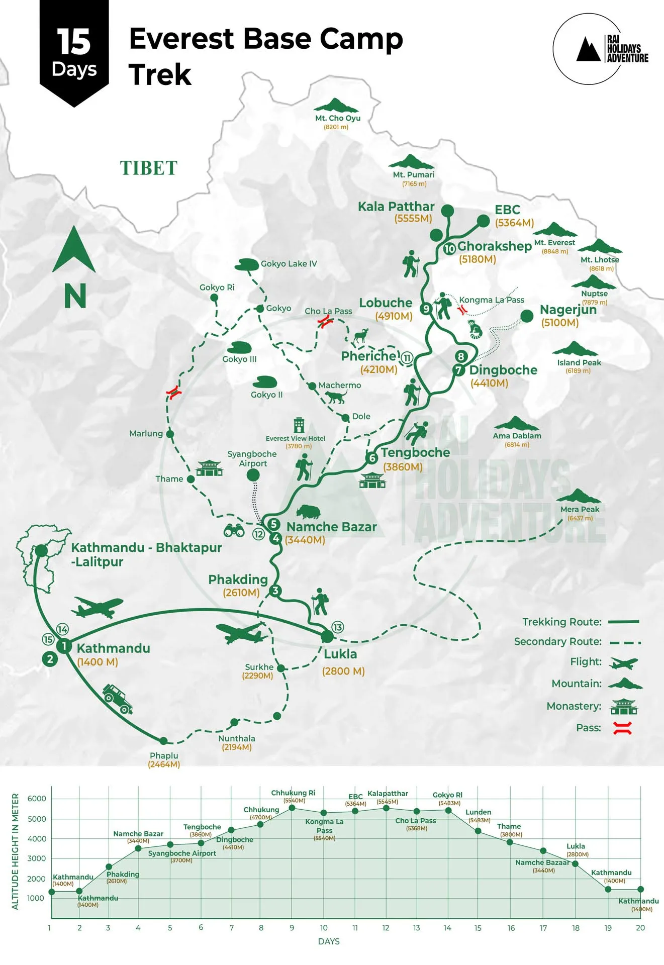
A good trek starts long before your boots touch the trail. Before walking toward the world’s highest mountain, it helps to understand the Everest Base Camp Trek Map. A map shows the main villages, walking routes, rivers, mountain passes, and high points along the journey. Knowing the route can help you prepare better and enjoy each day with more confidence.
Start Your Journey in Kathmandu
Most Everest Base Camp journeys begin in Kathmandu. This busy city is the main place to prepare for the trek. You can check your gear, meet your guide, and make final arrangements before heading toward the Everest region.
From Kathmandu, trekkers usually travel to Lukla by flight. Lukla is the starting point for the classic Everest Base Camp trail. From here, the route moves through mountain villages and peaceful valleys.
Follow the Trail to Namche Bazaar
After leaving Lukla, the trail passes through small villages and forests before reaching Namche Bazaar. Namche is one of the most important places on the route.
The village sits in a beautiful mountain valley and is a popular place for trekkers to rest. Many itineraries include an acclimatization day here. You can explore the village, enjoy mountain views, and allow your body to adjust to the higher altitude.
Continue Toward Tengboche
After Namche, the trail continues toward Tengboche. This part of the journey offers wonderful views of famous Himalayan peaks.
Tengboche is known for its beautiful monastery and peaceful setting. It is a great place to slow down and enjoy the mountain atmosphere. The map helps you understand where Tengboche sits in relation to Namche and the next stops on the trail.
Reach Dingboche and Lobuche
The trail then moves toward Dingboche. At this point, the landscape becomes more open and rugged. You will notice fewer trees and more rocky mountain scenery.
Dingboche is another common acclimatization stop. From there, the route continues toward Lobuche. The higher you go, the more important it becomes to walk slowly and listen to your body.
Looking at the map before your trek helps you understand how quickly the altitude increases. This can help you prepare for longer walking days and colder conditions.
The Final Route to Everest Base Camp
From Lobuche, the trail heads toward Gorak Shep. This is one of the highest settlements on the classic route. From Gorak Shep, trekkers make the final journey to Everest Base Camp.
Reaching Base Camp is a special moment. You can see the famous Khumbu Glacier and dramatic mountain scenery around you. The exact views can change with the season, but the feeling of reaching this famous destination remains unforgettable.
Many trekkers also climb Kala Patthar for some of the best panoramic views of Everest and the surrounding peaks.
Trek with Rai Holidays Adventure
Rai Holidays Adventure helps travelers prepare for the Everest Base Camp Trek with organized and reliable services. The company provides experienced trekking guides, porters, transportation arrangements, accommodation, permits, and trek preparation support.
A local guide can also help you understand the route shown on the map. They can explain the trail, help with daily plans, and provide support during the journey. Good planning is especially useful on a high-altitude trek where weather and trail conditions can change.
Why the Map Matters
An Everest Base Camp Trek Map is more than a picture of the route. It gives you a simple idea of where you will walk, how the altitude changes, and where you can stop each day.
You do not need to be an expert at reading maps. Just learn the main places and the order of the route. Knowing what comes next can make the trek feel less confusing and more exciting.
The Himalayas may be huge, but a good map can make the journey easier to understand. With proper preparation, a reliable guide, and a clear idea of the route, you can take each step toward Everest Base Camp with confidence.